The Technology Revolution Changing Archaeology
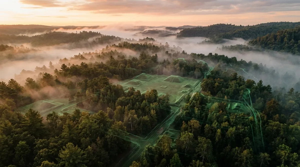
A quiet revolution is reshaping our understanding of ancient America, and it's happening from above. Light Detection and Ranging (lidar) technology is peeling back centuries of forest growth to reveal archaeological sites that have remained hidden beneath tree canopies across the United States.
Anthropologist-explorer Luke Caverns represents a new breed of researchers using this technology to map the invisible past. According to reports, Caverns has mapped over 82 possible archaeological sites across the U.S. using lidar data, focusing particularly on mound-builder settlements that predate European contact.
How Lidar Works in Archaeological Discovery
Lidar operates by sending laser pulses from aircraft or drones to measure distances to the ground below. What makes this technology revolutionary for archaeology is its ability to penetrate forest canopies and reveal the subtle elevation changes that indicate human-made structures. Ancient roads, earthworks, and settlement patterns that would be invisible to traditional aerial photography become clearly defined in lidar imagery.
The technology can detect features as subtle as low earthen mounds, ancient roadways, and defensive earthworks that have been obscured by centuries of vegetation growth. This capability is transforming how archaeologists approach site discovery, moving from ground-based surveys to landscape-scale analysis.
Reconstructing Ancient Worlds with Modern Tools
Caverns' approach goes beyond simple site identification. According to reports, his team plans to conduct high-resolution drone scans to rebuild mound-builder cities in three-dimensional models. This "outlaw archaeology" methodology combines lidar mapping with drones, 3D modeling, and artificial intelligence reconstruction to visualize lost ancient worlds.
This technological approach allows researchers to understand not just individual sites, but entire cultural landscapes. Ancient settlement patterns, road networks, and urban planning become visible when viewed through this technological lens.
The Amazon Frontier
The implications of this technology extend far beyond North America. According to reports, Caverns has proposed an Amazon project that could become the largest lidar scan ever conducted in that region. The Amazon basin represents perhaps the greatest frontier for lidar archaeology, where dense jungle canopy has concealed potential megasites and urban networks.
Recent Amazon discoveries using lidar have already gained significant public attention, revealing complex societies with sophisticated urban planning hidden beneath what was once thought to be pristine wilderness. These findings are rewriting assumptions about pre-Columbian civilizations and their environmental impact.
Democratizing Archaeological Discovery
What makes this technological revolution particularly interesting is how it's democratizing archaeological discovery. Independent researchers can now access public lidar datasets and use consumer-grade drones to conduct their own surveys. This represents a shift from traditional institutional archaeology to more accessible, technology-driven exploration.
The combination of publicly available data and affordable technology means that significant archaeological discoveries are no longer limited to well-funded academic expeditions. Citizen scientists and independent researchers can now contribute meaningfully to our understanding of ancient civilizations.
Understanding Ancient Settlement Patterns
The sites being revealed through lidar scanning tell a story of sophisticated ancient societies. Mound-builder cultures created complex settlement patterns with carefully planned earthworks, roads, and urban centers. These weren't simple villages but coordinated networks of settlements connected by transportation corridors.
The ability to see these patterns from above provides archaeologists with crucial context for understanding how ancient peoples organized their territories, managed resources, and structured their societies. Each newly mapped site adds another piece to the puzzle of pre-Columbian North American civilization.
The Future of Archaeological Exploration
As lidar technology becomes more accessible and AI reconstruction techniques improve, we can expect accelerating discoveries of hidden archaeological sites. The technology is particularly valuable in heavily forested regions where traditional archaeological survey methods are limited by visibility and accessibility.
This technological approach to archaeology represents more than just improved survey methods—it's fundamentally changing how we understand the relationship between ancient peoples and their landscapes. Sites that have remained invisible for centuries are now being revealed, offering new insights into the complexity and sophistication of pre-Columbian civilizations across the Americas.